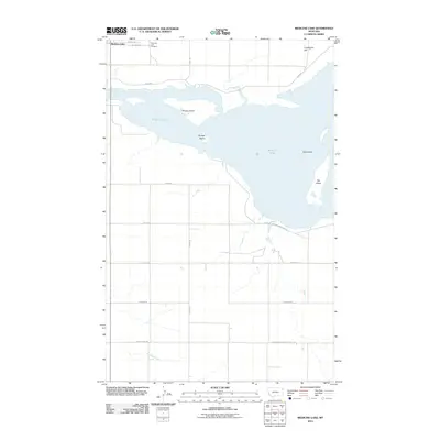
2011 Map of Medicine Lake
USGS Topo · Published 2011About this map
Medicine Lake dominates the northern landscape of this corner of Sheridan County, serving as a focal point for the surrounding high plains and the Medicine Lake Natl Wildl Refug. The shoreline is punctuated by several named landforms, including Umbrights Hill to the northeast and a series of islands such as Big Island, Bruces Island, and Gull Island. To the northwest, the settlement of Medicine Lake is established near the Medicine Lake Cemetery, also labeled as Lake Cemetery. The map captures a transition from the water-rich refuge areas to the highly structured agricultural grid to the south, defined by a network of rural roads including Longview, Bakken, and Big Lake Rd. McCabe Creek winds through the southern reaches, crossing the Sheridan-Roosevelt County Rd which marks the regional boundary line.
Find a feature on this map
20 named features on this map. Tap any name to fly to it.
Don’t see what you’re looking for? This feature index may not catch every label — zoom into the map to look around manually.
Map Details
Editions of this 2011 Medicine Lake Map
This is the sole edition of this map. No revisions or reprints were ever made.
Other maps of this area

1914 · Homestead
USGS Topo · 1:62,500

1947 · Capeneys Lake
USGS Topo · 1:24,000

1947 · Homestead
USGS Topo · 1:24,000

1948 · Homestead
USGS Topo · 1:24,000

1948 · Capeneys Lake
USGS Topo · 1:24,000

1948 · Reserve SE
USGS Topo · 1:24,000

1948 · Medicine Lake
USGS Topo · 1:24,000

1948 · Reserve
USGS Topo · 1:24,000

1948 · Alkali Coulee
USGS Topo · 1:24,000

1949 · Reserve SE
USGS Topo · 1:24,000