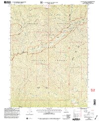
2001 Map of Medicine Mountain
USGS Topo · Published 2004About this map
Medicine Mtn stands as a central peak in this high-elevation landscape within the Klamath National Forest. The map documents a primitive network of outposts including Fowler Cabin and several remote campsites like Bear Skull Camp and North Fork Camp, which served as critical access points for forest management and backcountry travel. The confluence of Wooley Creek and the Klamath River dictates the drainage patterns of the western portion, while the Marble Mountain Wilderness protects the upper reaches of Yellow Jacket Creek.
Find a feature on this map
37 named features on this map. Tap any name to fly to it.
Don’t see what you’re looking for? This feature index may not catch every label — zoom into the map to look around manually.
Map Details
Editions of this 2001 Medicine Mountain Map
This is the sole edition of this map. No revisions or reprints were ever made.
Other maps of this area

1914 · Seiad
USGS Topo · 1:125,000

1922 · Seiad
USGS Topo · 1:125,000

1948 · Weed
USGS Topo · 1:250,000

1950 · Weed
USGS Topo · 1:250,000

1955 · Sawyers Bar
USGS Topo · 1:62,500

1955 · Ukonom Lake
USGS Topo · 1:62,500

1955 · Scott Bar
USGS Topo · 1:62,500

1955 · Forks of Salmon
USGS Topo · 1:62,500

1958 · Weed
USGS Topo · 1:250,000

1963 · Weed
USGS Topo · 1:250,000