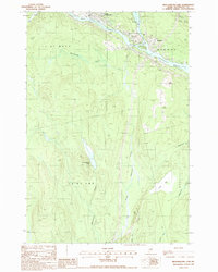
1988 Map of Medunkeunk Lake
USGS Topo · Published 1988About this map
West Branch Penobscot River flows through the northern reaches of this township, where the industrial infrastructure of East Millinocket and Medway meets the wooded landscape of Penobscot County. The confluence at Nicatou I serves as a focal point for local geography, while a series of water bodies like Medunkeunk Lake and Inman Bog characterize the low-lying interior.
Find a feature on this map
30 named features on this map. Tap any name to fly to it.
Don’t see what you’re looking for? This feature index may not catch every label — zoom into the map to look around manually.
Map Details
Editions of this 1988 Medunkeunk Lake Map
This is the sole edition of this map. No revisions or reprints were ever made.
Other maps of this area

1920 · Winn
USGS Topo · 1:62,500

1940 · Mattawamkeag
USGS Topo · 1:62,500

1942 · Lincoln
USGS Topo · 1:62,500

1942 · Mattawamkeag
USGS Topo · 1:62,500

1951 · Millinocket
USGS Topo · 1:62,500

1954 · Millinocket
USGS Topo · 1:250,000

1957 · Lincoln
USGS Topo · 1:62,500

1958 · Millinocket
USGS Topo · 1:250,000

1960 · Millinocket
USGS Topo · 1:250,000
1960 · Winn
USGS Topo · 1:62,500