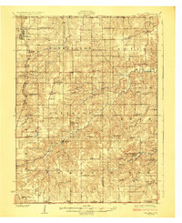
1924 Map of Melcher
USGS Topo · Published 1924About this map
Dallas and Melcher anchor the northwestern corner of this territory, where the Chicago Burlington and Quincy RR cuts across the landscape. The region's early 20th-century economy is visibly rooted in extraction, evidenced by Mine No 4 and Mine No 18 located near the small settlements of Tipperary and Olmitz. Numerous small rural schools, including Washington School and Brush College School, are spaced throughout the townships, serving the farm families that populated the area before the era of district consolidation.
Find a feature on this map
81 named features on this map. Tap any name to fly to it.
Don’t see what you’re looking for? This feature index may not catch every label — zoom into the map to look around manually.
Map Details
Editions of this 1924 Melcher Map
3 editions found
Other maps of this area

1909 · Knoxville
USGS Topo · 1:62,500

1910 · Milo
USGS Topo · 1:62,500

1910 · Pella
USGS Topo · 1:62,500

1912 · Knoxville
USGS Topo · 1:62,500

1912 · Pella
USGS Topo · 1:62,500

1918 · Chariton
USGS Topo · 1:62,500

1924 · Melcher
USGS Topo · 1:62,500

1929 · Albia
USGS Topo · 1:62,500

1934 · Humeston
USGS Topo · 1:48,000

1935 · Russell
USGS Topo · 1:62,500