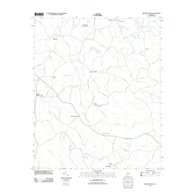
2011 Map of Mellow Valley
USGS Topo · Published 2011About this map
Cooley Crossroads and Mellow Valley serve as the primary nodes of this East Alabama landscape, where several rural communities are linked by a dense network of country roads. The topography is defined by significant ridges like White Oak Mountain and Evan Ridge, which separate the various drainage basins of Wesobulga Creek, Hurricane Creek, and Emuckfaw Creek. Genealogists will find a high concentration of burial sites, including the Jehovah Cemetery and Mount Gilead Cemetery, which help document the historical settlement pattern of the area. This 2011 survey also records modern land use and infrastructure, such as the Blackjack Lookout Tower and the Crooked Creek Watershed Dam Number 16, showing how local resources are managed. The southwestern portion of the map is particularly notable for its extensive system of logging roads, such as Logging Rd 17, indicating the continued importance of the timber industry to the Clay County economy.
Find a feature on this map
93 named features on this map. Tap any name to fly to it.
Don’t see what you’re looking for? This feature index may not catch every label — zoom into the map to look around manually.
Map Details
Editions of this 2011 Mellow Valley Map
This is the sole edition of this map. No revisions or reprints were ever made.
Other maps of this area

1891 · Ashland
USGS Topo · 1:125,000

1953 · Atlanta
USGS Topo · 1:250,000

1957 · Atlanta
USGS Topo · 1:250,000

1958 · Atlanta
USGS Topo · 1:250,000

1969 · New Site
USGS Topo · 1:24,000

1969 · Wadley North
USGS Topo · 1:24,000

1969 · Gibsonville
USGS Topo · 1:24,000
1969 · Daviston
USGS Topo · 1:24,000
1969 · Wadley South
USGS Topo · 1:24,000

1969 · Mellow Valley
USGS Topo · 1:24,000