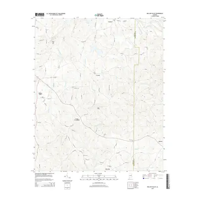
2014 Map of Mellow Valley
USGS Topo · Published 2014About this map
Cooley Crossroads and Mellow Valley anchor this portrait of the rural landscape along the border of Clay and Randolph Counties. The terrain is defined by the prominent White Oak Mtn and the long stretch of Evan Ridge, which separate the various drainage basins of the Piedmont. Small, dispersed settlements like Corinth, Sikesville, and Almond are connected by a network of local roads such as Corinth Rd and Spring Rd, reflecting a community structure built around farming and local industry.
Find a feature on this map
102 named features on this map. Tap any name to fly to it.
Don’t see what you’re looking for? This feature index may not catch every label — zoom into the map to look around manually.
Map Details
Editions of this 2014 Mellow Valley Map
This is the sole edition of this map. No revisions or reprints were ever made.
Other maps of this area

1891 · Ashland
USGS Topo · 1:125,000

1953 · Atlanta
USGS Topo · 1:250,000

1957 · Atlanta
USGS Topo · 1:250,000

1958 · Atlanta
USGS Topo · 1:250,000

1969 · New Site
USGS Topo · 1:24,000

1969 · Wadley North
USGS Topo · 1:24,000

1969 · Gibsonville
USGS Topo · 1:24,000
1969 · Daviston
USGS Topo · 1:24,000
1969 · Wadley South
USGS Topo · 1:24,000

1969 · Mellow Valley
USGS Topo · 1:24,000