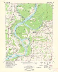
1962 Map of Mellwood
USGS Topo · Published 1962About this map
The Mississippi River dominates this early 1960s survey, revealing a landscape defined by its historical flood control and river engineering. The map documents significant hydrological changes through the Jackson Cut-Off (1941) and Sunflower Cut-Off (1942), which bypass the older meanders of Sunflower Bend. Evidence of the river's power remains etched in the terrain at the Laconia Crevasse (1913) and the Knowlton Crevasse (1916) (Knowlton Blue Hole).
Find a feature on this map
93 named features on this map. Tap any name to fly to it.
Don’t see what you’re looking for? This feature index may not catch every label — zoom into the map to look around manually.
Map Details
Editions of this 1962 Mellwood Map
This is the sole edition of this map. No revisions or reprints were ever made.
Other maps of this area

1930 · Mellwood
USGS Topo · 1:62,500

1931 · Drew
USGS Topo · 1:48,000

1935 · Clarksdale
USGS Topo · 1:62,500

1935 · Mound Bayou
USGS Topo · 1:62,500

1939 · Farrell
USGS Topo · 1:62,500

1939 · Modoc
USGS Topo · 1:62,500

1939 · Indian Bay
USGS Topo · 1:62,500

1939 · Henrico
USGS Topo · 1:62,500

1939 · Pace
USGS Topo · 1:62,500

1939 · Clarksdale
USGS Topo · 1:62,500