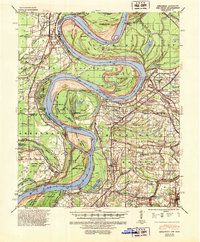
1939 Map of Mellwood
USGS Topo · Published 1952About this map
The Missouri Pacific railroad line anchors the Arkansas side of this riverine landscape, connecting the town of Mellwood and the agricultural settlement of Lundell. This 1930s-era topography reveals a complex network of bayous and meander lines along the border of Arkansas and Mississippi, featuring distinctive river engineering works such as the Avenue Revet and Knowlton Revetment. The map is particularly rich in genealogical data for the region, documenting numerous rural churches and schools including Jerusalem Ch & Cem and the Booker Sch & Cem. Significant water bodies like Moon Lake and the serpentine Hushpuckena River define the Delta terrain. A rare feature shown is the Laconia Circle in Desha County, illustrating early land patterns within the loops of the shifting river. From Hurricane Pt to the bends around Island No 64, the map documents a landscape shaped by both natural flooding and deliberate flood control efforts.
Find a feature on this map
71 named features on this map. Tap any name to fly to it.
Don’t see what you’re looking for? This feature index may not catch every label — zoom into the map to look around manually.
Map Details
Editions of this 1939 Mellwood Map
2 editions found

Other maps of this area

1930 · Mellwood
USGS Topo · 1:62,500

1931 · Drew
USGS Topo · 1:48,000

1935 · Clarksdale
USGS Topo · 1:62,500

1935 · Mound Bayou
USGS Topo · 1:62,500

1939 · Farrell
USGS Topo · 1:62,500

1939 · Modoc
USGS Topo · 1:62,500

1939 · Indian Bay
USGS Topo · 1:62,500

1939 · Henrico
USGS Topo · 1:62,500

1939 · Pace
USGS Topo · 1:62,500

1939 · Clarksdale
USGS Topo · 1:62,500