
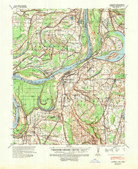
1939 Map of Farrell
USGS Topo · Published 1941About this map
Friar Point stands as a significant river landing along the winding Mississippi River in this pre-war survey of Coahoma County. The landscape is defined by the shifting course of the river, notably the Horseshoe Cut-Off 1848 and various oxbows like Moon Lake and Old Town Lake. The agrarian economy of the Mississippi Delta is evident in the numerous tenant settlements and plantations, such as Elkhorn Place and Preston Places, which are supported by a dense network of country schools and churches like Paradise Ch & Sch and St Stephens Ch & Sch. Transportation for the region's cotton and timber is facilitated by the Illinois Central and Memphis & Vicksburg railroads. The map also captures several family-named locations such as Stovall, Dickerson, and Humber, providing essential data for genealogists tracing local lineage in the Phillips County and Coahoma borderlands.
Find a feature on this map
73 named features on this map. Tap any name to fly to it.
Don’t see what you’re looking for? This feature index may not catch every label — zoom into the map to look around manually.
Map Details
Editions of this 1939 Farrell Map
2 editions found
Other maps of this area

1908 · Lula
USGS Topo · 1:24,000

1908 · Dundee
USGS Topo · 1:24,000

1908 · Coahoma
USGS Topo · 1:24,000

1908 · Moon Lake
USGS Topo · 1:24,000

1908 · Jonestown
USGS Topo · 1:24,000

1910 · Dundee
USGS Topo · 1:31,680

1910 · Coahoma
USGS Topo · 1:31,680

1910 · Jonestown
USGS Topo · 1:31,680

1912 · Moon Lake
USGS Topo · 1:31,680

1912 · Lula
USGS Topo · 1:31,680