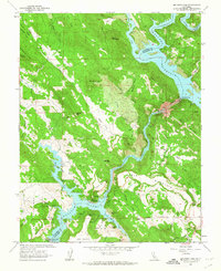
1962 Map of Melones Dam
USGS Topo · Published 1963About this map
Melones Reservoir and Tulloch Lake dominate this 1960s landscape, illustrating the mid-century transformation of the Stanislaus River for water resource management. The geography is defined by significant elevation changes, from the depths of Iron Canyon to peaks like Lightner Peak and the prominent plateau of Table Mountain. This era shows a transition in land use, where older extractive industries like the Lightner Mine and Valencia Mine are surrounded by modern infrastructure, including the Melones Dam and Tulloch Dam. Historical river crossings are remembered at the Central Ferry (Site) and the Byrne Ferry Historical Monument, while an old railroad grade traces earlier transit patterns through the canyon walls. The rugged boundary between Calaveras and Tuolumne counties follows the river's original course, winding past family-named sites like Wagner Ranch.
Find a feature on this map
72 named features on this map. Tap any name to fly to it.
Don’t see what you’re looking for? This feature index may not catch every label — zoom into the map to look around manually.
Map Details
Editions of this 1962 Melones Dam Map
4 editions found
Other maps of this area

1889 · Jackson
USGS Topo · 1:125,000

1891 · Big Trees
USGS Topo · 1:125,000

1892 · Jackson
USGS Topo · 1:125,000

1893 · Sonora
USGS Topo · 1:125,000

1894 · Big Trees
USGS Topo · 1:125,000

1896 · Sonora
USGS Topo · 1:125,000

1897 · Jackson
USGS Topo · 1:125,000

1897 · Sonora
USGS Topo · 1:125,000

1897 · Big Trees
USGS Topo · 1:125,000

1898 · Sonora
USGS Topo · 1:125,000
Featured Places
- The Shores of Poker Flat, CA
- Black Jack Bluffs, CA
- Tuolumne County, CA
- Calaveras County, CA
- United States