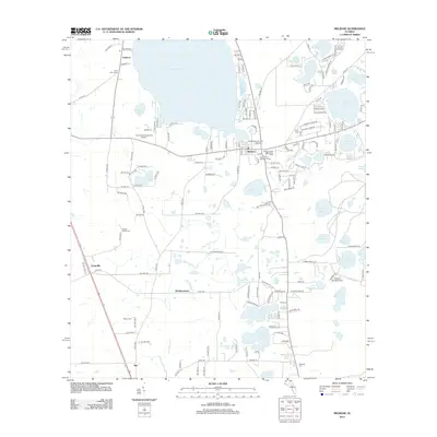
2012 Map of Melrose
USGS Topo · Published 2012About this map
Santa Fe Lake and the smaller Lake Melrose dominate the northern landscape of this region, where the clustered community of Melrose serves as a hub near the Alachua county line. The map reveals a high density of cemeteries that speak to the area's genealogical history, including Eliam Cem of Melrose Florida and the family-named Nelson - Starke Cem. The topography is defined by its lacustrine character, with numerous water bodies like Lake Hutchinson, Lake Rosa, and Lake Rowan scattered throughout the pine-flatwoods and prairie landscape. To the south, smaller settlements like Beckhamtown and Rex are situated among agricultural tracts and features such as Fawlers Prairie. Local infrastructure includes distinct landmarks like the Melrose Water Association Tower and private aviation strips such as The Flying Horseman Airport and Sanders Ranch Airport.
Find a feature on this map
159 named features on this map. Tap any name to fly to it.
Don’t see what you’re looking for? This feature index may not catch every label — zoom into the map to look around manually.
Map Details
Editions of this 2012 Melrose Map
This is the sole edition of this map. No revisions or reprints were ever made.
Other maps of this area

1915 · Interlachen
USGS Topo · 1:48,000

1916 · Interlachen
USGS Topo · 1:62,500

1938 · Hawthorn
USGS Topo · 1:48,000

1941 · Starke
USGS Topo · 1:62,500

1942 · Ates Creek
USGS Topo · 1:62,500

1943 · Hawthorn
USGS Topo · 1:62,500

1944 · Interlachen
USGS Topo · 1:62,500

1948 · Starke
USGS Topo · 1:50,000

1949 · Keuka
USGS Topo · 1:24,000

1949 · Gold Head Branch
USGS Topo · 1:24,000