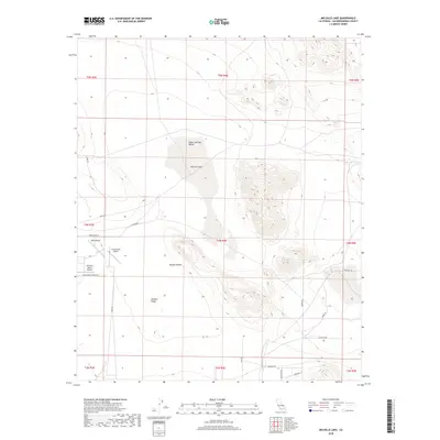
2018 Map of Melville Lake
USGS Topo · Published 2018About this map
Melville Lake lies at the center of this 2018 study of the Mojave Desert floor, situated within the Upper Johnson Valley. The landscape is defined by the ephemeral dry lake bed and a network of unpaved roads and trails that serve a scattered high-desert community. Aviation plays a clear role in the local infrastructure, with several private landing strips including Kelly Airport, B & E Ranch Airport, and Abraham Ranch Airport concentrated in the western portion of the quadrangle. These features, along with names like Mustang Trl and Pistachio Rd, suggest a mix of ranching heritage and recreational desert living near Johnson Valley. The map detail traces the exact alignment of access routes like Cottonwood Springs Rd and Pony Rd as they navigate the arid terrain.
Find a feature on this map
28 named features on this map. Tap any name to fly to it.
Don’t see what you’re looking for? This feature index may not catch every label — zoom into the map to look around manually.
Map Details
Editions of this 2018 Melville Lake Map
This is the sole edition of this map. No revisions or reprints were ever made.
Other maps of this area

1901 · Southern California Sheet No. 1
USGS Topo · 1:250,000

1902 · San Gorgonio
USGS Topo · 1:125,000

1904 · Southern California Sheet No. 1
USGS Topo · 1:250,000

1953 · San Bernardino
USGS Topo · 1:250,000

1954 · Galway Lake
USGS Topo · 1:24,000

1954 · Emerson Lake
USGS Topo · 1:24,000

1955 · Old Woman Springs
USGS Topo · 1:62,500

1955 · Lavic
USGS Topo · 1:62,500

1955 · Emerson Lake
USGS Topo · 1:62,500

1955 · Rodman Mountains
USGS Topo · 1:62,500