
1989 Map of Mena
USGS Topo · Published 1991About this map
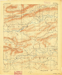
The Ouachita Mountains dominate this 1989 survey, where the rugged topography of western Arkansas meets eastern Oklahoma. This landscape is defined by the sharp, east-west orientation of ridges like Rich Mountain and the Winding Stair Mountain, creating a natural corridor for the Kansas City Southern RR. The regional hub of Mena anchors the eastern side of the sheet, serving as a gateway to the Ouachita National Forest and the high-elevation Queen Wilhelmina State Park.
Find a feature on this map
163 named features on this map. Tap any name to fly to it.
Don’t see what you’re looking for? This feature index may not catch every label — zoom into the map to look around manually.
Map Details
Editions of this 1989 Mena Map
This is the sole edition of this map. No revisions or reprints were ever made.
Other maps of this area

1879 · Poteau Mountain
USGS Topo · 1:62,500

1887 · Poteau Mountain #1
USGS Topo · 1:62,500

1887 · Mount Ida #2
USGS Topo · 1:62,500

1887 · Magazine Mountain #3
USGS Topo · 1:62,500

1887 · Magazine Mountain
USGS Topo · 1:62,500

1887 · Poteau Mountain #2
USGS Topo · 1:62,500

1887 · Greenwood
USGS Topo · 1:62,500

1890 · Magazine Mountain
USGS Topo · 1:125,000
1890 · Mount Ida
USGS Topo · 1:125,000

1890 · Fort Smith
USGS Topo · 1:125,000