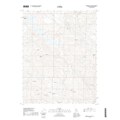
2018 Map of Mendenhall Springs
USGS Topo · Published 2018About this map
Mendenhall Springs is situated in a rugged, ridge-dominated portion of the Diablo Range in eastern Alameda County. The landscape is defined by its dramatic relief, where the steep elevations of Rocky Ridge, Crane Ridge, and Cedar Mtn Ridge converge. Central to the area’s geography is Lake del Valle, a reservoir fed by the Arroyo Valle and Arroyo Mocho drainages. The Hetch Hetchy Aqueduct cuts through the northern section, marking a critical piece of California's water infrastructure as it passes through the hills. This 2018 survey also identifies significant high points such as Rose Peak and Discovery Peak, which tower over the deep canyons of Lang Canyon and Williams Gulch. The map reveals a land predominantly shaped by hydrological management and physical geography, with sparsely winding routes like Mines Rd providing rare access into the interior.
Find a feature on this map
42 named features on this map. Tap any name to fly to it.
Don’t see what you’re looking for? This feature index may not catch every label — zoom into the map to look around manually.
Map Details
Editions of this 2018 Mendenhall Springs Map
This is the sole edition of this map. No revisions or reprints were ever made.
Other maps of this area

1889 · San Jose
USGS Topo · 1:62,500

1897 · San Jose
USGS Topo · 1:62,500

1897 · Mt. Hamilton
USGS Topo · 1:62,500

1899 · San Jose
USGS Topo · 1:62,500

1906 · Pleasanton
USGS Topo · 1:62,500

1907 · Tesla
USGS Topo · 1:62,500

1916 · Midway
USGS Topo · 1:31,680

1941 · Pleasanton
USGS Topo · 1:62,500

1942 · Mt. Hamilton
USGS Topo · 1:62,500

1942 · Altamont
USGS Topo · 1:62,500