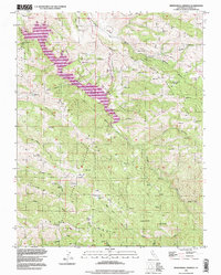
1996 Map of Mendenhall Springs
USGS Topo · Published 1998About this map
Del Valle Regional Park dominates the northwestern portion of this 1996 update, where the reservoir waters are framed by the steep slopes of Wauhab Ridge and Crane Ridge. This landscape in eastern Alameda County is defined by its water management and transit infrastructure, most notably the path of the Hetch Hetchy Aqueduct and the presence of several isolated mountain flats. The settlement at Mendenhall Springs and high-altitude clearings like Shafer Flat and Rose Flat indicate a history of upland ranching or seasonal habitation.
Find a feature on this map
30 named features on this map. Tap any name to fly to it.
Don’t see what you’re looking for? This feature index may not catch every label — zoom into the map to look around manually.
Map Details
Editions of this 1996 Mendenhall Springs Map
This is the sole edition of this map. No revisions or reprints were ever made.
Other maps of this area

1889 · San Jose
USGS Topo · 1:62,500

1897 · San Jose
USGS Topo · 1:62,500

1897 · Mt. Hamilton
USGS Topo · 1:62,500

1899 · San Jose
USGS Topo · 1:62,500

1906 · Pleasanton
USGS Topo · 1:62,500

1907 · Tesla
USGS Topo · 1:62,500

1916 · Midway
USGS Topo · 1:31,680

1941 · Pleasanton
USGS Topo · 1:62,500

1942 · Mt. Hamilton
USGS Topo · 1:62,500

1942 · Altamont
USGS Topo · 1:62,500