
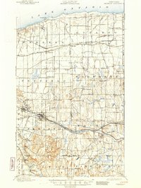
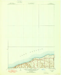
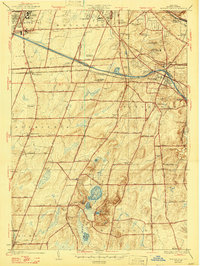
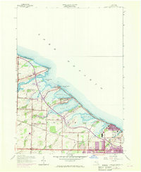
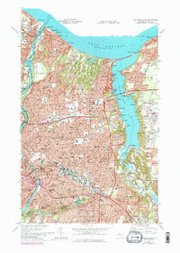
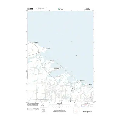
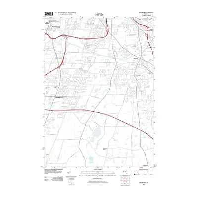
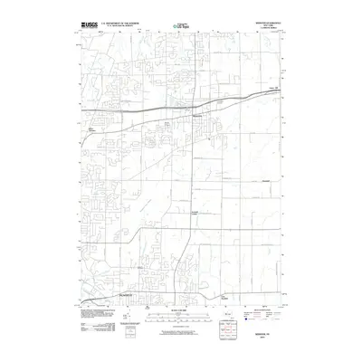
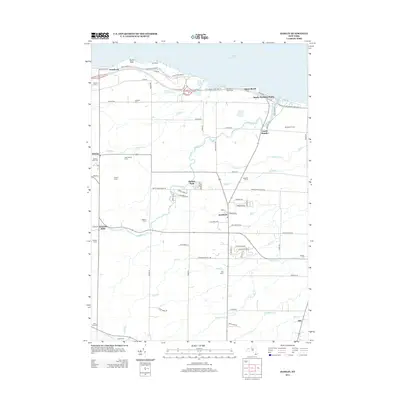
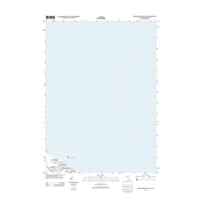
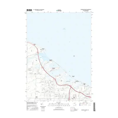
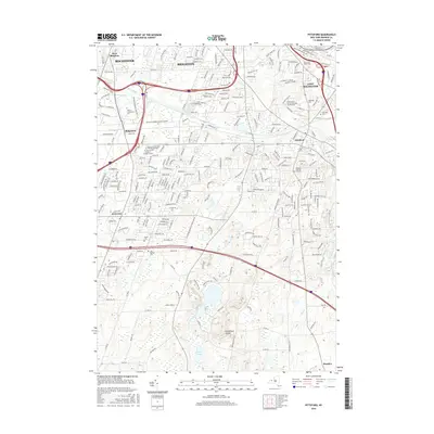
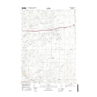
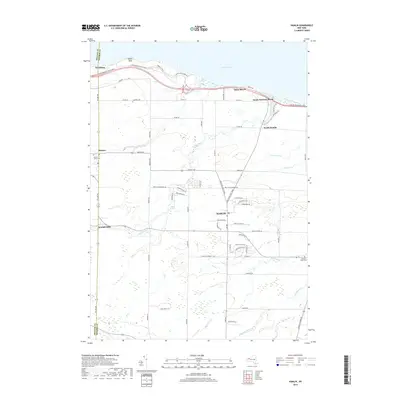
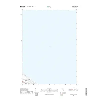
1931 Map of Mendon Ponds
USGS Topo · Published 1931About this map
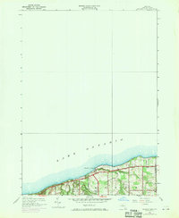
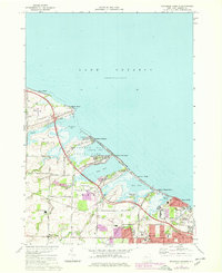
The southern periphery of the City of Rochester meets the glacial kettle-and-kame landscape of the Mendon Ponds Park area in this 1931 survey. Large institutional footprints dominate the northwestern corner, including the State Hospital, the Monroe County Penitentiary, and the Iola Sanitarium, indicating a concentrated zone of public health and carceral architecture at the city's edge. The transportation network is defined by the Barge Canal and the New York Central and Hudson River RR, which supported the industrial growth of satellite towns like Pittsford and East Rochester.
Find a feature on this map
57 named features on this map. Tap any name to fly to it.
Don’t see what you’re looking for? This feature index may not catch every label — zoom into the map to look around manually.
Map Details
Editions of this 1931 Mendon Ponds Map
This is the sole edition of this map. No revisions or reprints were ever made.
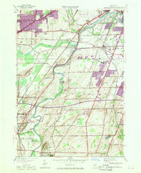
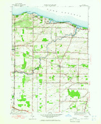
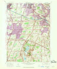
Historical Maps of Rochester Through Time
91 maps found

1895 Ontario Beach
Monroe County, NY

1899 Bergen
Monroe County, NY
1899 Hamlin
Monroe County, NY
1899 Ontario Beach
Monroe County, NY
1900 Macedon
Monroe County, NY

1912 Ontario Beach
Monroe County, NY
1931 Mendon Ponds
Monroe County, NY

1931 Rochester East
Monroe County, NY

1931 Rochester West
Monroe County, NY

1932 Hamlin
Monroe County, NY

1932 Webster
Monroe County, NY
1934 Braddock Heights
Monroe County, NY

1934 Clifton
Monroe County, NY
1934 Ninemile Point
Monroe County, NY
1934 Webster
Monroe County, NY
1935 Genesee Junction
Monroe County, NY
1935 Hamlin
Monroe County, NY
1935 Mendon Ponds
Monroe County, NY
1935 Rochester East
Monroe County, NY
1935 Rochester West
Monroe County, NY
1950 Clifton
Monroe County, NY
1952 Braddock Heights
Monroe County, NY
1952 Genesee Junction
Monroe County, NY
1952 Hamlin
Monroe County, NY
1952 Mendon Ponds
Monroe County, NY
1952 Ninemile Point
Monroe County, NY
1952 Rochester East
Monroe County, NY
1952 Rochester West
Monroe County, NY
1952 Webster
Monroe County, NY
1971 Braddock Heights
Monroe County, NY
1971 Clifton
Monroe County, NY

1971 Hamlin
Monroe County, NY
1971 Ninemile Point
Monroe County, NY
1971 Pittsford
Monroe County, NY
1971 Rochester East
Monroe County, NY
1971 Rochester West
Monroe County, NY

1971 Webster
Monroe County, NY
1971 West Henrietta
Monroe County, NY

1978 Hamlin
Monroe County, NY
1994 Pittsford
Monroe County, NY

1994 Rochester West
Monroe County, NY
2010 Braddock Heights
Monroe County, NY
2010 Clifton
Monroe County, NY
2010 Hamlin
Monroe County, NY
2010 Ninemile Point
Monroe County, NY
2010 Pittsford
Monroe County, NY
2010 Rochester East
Monroe County, NY
2010 Rochester East OE N
Monroe County, NY
2010 Rochester West
Monroe County, NY
2010 Webster
Monroe County, NY
2010 West Henrietta
Monroe County, NY
2013 Braddock Heights
Monroe County, NY
2013 Clifton
Monroe County, NY
2013 Hamlin
Monroe County, NY
2013 Ninemile Point
Monroe County, NY
2013 Pittsford
Monroe County, NY
2013 Rochester East
Monroe County, NY
2013 Rochester East OE N
Monroe County, NY
2013 Rochester West
Monroe County, NY
2013 Webster
Monroe County, NY
2013 West Henrietta
Monroe County, NY
2016 Braddock Heights
Monroe County, NY
2016 Clifton
Monroe County, NY
2016 Hamlin
Monroe County, NY
2016 Ninemile Point
Monroe County, NY
2016 Pittsford
Monroe County, NY
2016 Rochester East
Monroe County, NY
2016 Rochester East OE N
Monroe County, NY
2016 Rochester West
Monroe County, NY
2016 Webster
Monroe County, NY
2016 West Henrietta
Monroe County, NY
2019 Braddock Heights
Monroe County, NY
2019 Clifton
Monroe County, NY
2019 Hamlin
Monroe County, NY
2019 Ninemile Point
Monroe County, NY
2019 Pittsford
Monroe County, NY
2019 Rochester East
Monroe County, NY
2019 Rochester East OE N
Monroe County, NY
2019 Rochester West
Monroe County, NY
2019 Webster
Monroe County, NY
2019 West Henrietta
Monroe County, NY

2023 Braddock Heights
Monroe County, NY

2023 Clifton
Monroe County, NY

2023 Hamlin
Monroe County, NY

2023 Ninemile Point
Monroe County, NY

2023 Pittsford
Monroe County, NY

2023 Rochester East
Monroe County, NY

2023 Rochester East OE N
Monroe County, NY

2023 Rochester West
Monroe County, NY

2023 Webster
Monroe County, NY

2023 West Henrietta
Monroe County, NY