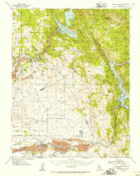
1954 Map of Merced Falls
USGS Topo · Published 1956About this map
The Merced River and its industrial transformation dominate this mid-century landscape where Mariposa, Tuolumne, Stanislaus, and Merced Counties converge. The map documents the significant footprint of the gold mining and water management eras, notably the extensive Dredge Tailings and Tailings fields that flank the river near Snelling. These massive mounds of gravel remain as physical evidence of the dredging operations that reconfigured the valley floor. To the north and east, the rising foothills are defined by the early phases of the region's reservoir systems, including the Don Pedro Reservoir and Lake McClure.
Find a feature on this map
80 named features on this map. Tap any name to fly to it.
Don’t see what you’re looking for? This feature index may not catch every label — zoom into the map to look around manually.
Map Details
Editions of this 1954 Merced Falls Map
This is the sole edition of this map. No revisions or reprints were ever made.
Other maps of this area

1893 · Sonora
USGS Topo · 1:125,000

1896 · Sonora
USGS Topo · 1:125,000

1897 · Sonora
USGS Topo · 1:125,000

1898 · Sonora
USGS Topo · 1:125,000

1913 · Dickenson
USGS Topo · 1:31,680

1915 · La Grange
USGS Topo · 1:24,000

1916 · Three Tree Flat
USGS Topo · 1:31,680

1916 · Hopeton
USGS Topo · 1:31,680

1916 · Cooperstown
USGS Topo · 1:31,680

1916 · Copperopolis
USGS Topo · 1:62,500