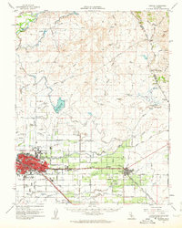
1962 Map of Merced
USGS Topo · Published 1963About this map
Merced sits at the heart of this agricultural and transportation corridor in the early 1960s, a landscape defined by the intersection of the Southern Pacific and the Atchison Topeka and Santa Fe railroads. The city's expansion is visible in its collection of mid-century institutions, including El Capitan High Sch and Evergreen Sch, while the surrounding plains are punctuated by small rail-side settlements like Planada, Tuttle, and Kadota.
Find a feature on this map
78 named features on this map. Tap any name to fly to it.
Don’t see what you’re looking for? This feature index may not catch every label — zoom into the map to look around manually.
Map Details
Editions of this 1962 Merced Map
This is the sole edition of this map. No revisions or reprints were ever made.
Other maps of this area

1893 · Sonora
USGS Topo · 1:125,000

1896 · Sonora
USGS Topo · 1:125,000

1897 · Sonora
USGS Topo · 1:125,000

1898 · Sonora
USGS Topo · 1:125,000

1913 · Dickenson
USGS Topo · 1:31,680

1914 · Merced
USGS Topo · 1:31,680

1915 · Owens Creek
USGS Topo · 1:31,680

1916 · Three Tree Flat
USGS Topo · 1:31,680

1916 · Hopeton
USGS Topo · 1:31,680

1916 · Merced Falls
USGS Topo · 1:24,000