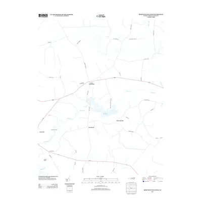
2013 Map of Merchants Millpond
USGS Topo · Published 2013About this map
Merchants Millpond State Park anchors this coastal plain landscape in Gates County, where the sprawling waters of Merchants Millpond are fed by Bennetts Cr. The geography is defined by a dense network of blackwater streams and wetlands, including Duke Swamp and Flat Branch, which intersect with a rural road system connecting small settlements like Eason Crossroads and Silver Springs. Historical land use is evident in the naming of features such as Sandy Field Landing and Hermit Island, suggesting a long relationship with the local riverine environment. The presence of the Chesapeake Lookout Tower and the Middle Swamp Hunt Clb highlights the area's ongoing importance for forestry and managed recreation. In the western reaches, the edge of Gatesville marks the transition toward more concentrated settlement near the county seat.
Find a feature on this map
40 named features on this map. Tap any name to fly to it.
Don’t see what you’re looking for? This feature index may not catch every label — zoom into the map to look around manually.
Map Details
Editions of this 2013 Merchants Millpond Map
This is the sole edition of this map. No revisions or reprints were ever made.
Other maps of this area

1906 · Beckford
USGS Topo · 1:48,000

1907 · Beckford
USGS Topo · 1:62,500

1908 · Winton
USGS Topo · 1:62,500

1919 · Suffolk
USGS Topo · 1:62,500

1920 · Holland
USGS Topo · 1:62,500

1940 · Beckford
USGS Topo · 1:62,500

1943 · Holland
USGS Topo · 1:62,500

1953 · Norfolk
USGS Topo · 1:250,000

1954 · Corapeake
USGS Topo · 1:24,000
1954 · Suffolk
USGS Topo · 1:62,500