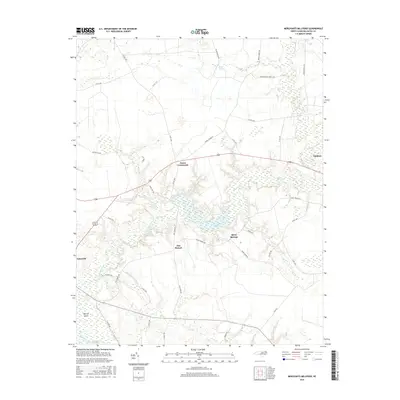
2016 Map of Merchants Millpond
USGS Topo · Published 2016About this map
Merchants Millpond sits at the heart of this coastal plain landscape, where a complex network of wetlands including Lassiter Swamp and Duke Swamp converge into Bennetts Cr. The 2016 survey illustrates a rural region characterized by small crossroads communities and family-named landmarks. The settlement of Sunbury occupies the northeastern corner, while the seat of Gatesville is situated to the southwest. The presence of the Middle Swamp Hunt Club and numerous swamp-bordering roads like Honey Pot Rd and Cotton Gin Rd reflect a landscape deeply tied to the local timber and water resources. Local navigation is defined by these waterways, with Hermit Island and the Flat Branch providing distinct points of reference within the hydrologic system that dominates the Gates County interior.
Find a feature on this map
41 named features on this map. Tap any name to fly to it.
Don’t see what you’re looking for? This feature index may not catch every label — zoom into the map to look around manually.
Map Details
Editions of this 2016 Merchants Millpond Map
This is the sole edition of this map. No revisions or reprints were ever made.
Other maps of this area

1906 · Beckford
USGS Topo · 1:48,000

1907 · Beckford
USGS Topo · 1:62,500

1908 · Winton
USGS Topo · 1:62,500

1919 · Suffolk
USGS Topo · 1:62,500

1920 · Holland
USGS Topo · 1:62,500

1940 · Beckford
USGS Topo · 1:62,500

1943 · Holland
USGS Topo · 1:62,500

1953 · Norfolk
USGS Topo · 1:250,000

1954 · Corapeake
USGS Topo · 1:24,000
1954 · Suffolk
USGS Topo · 1:62,500