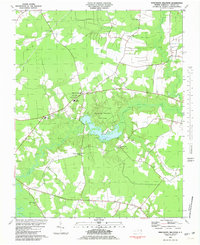
1981 Map of Merchants Millpond
USGS Topo · Published 1981About this map
Merchants Millpond State Park anchors this coastal plain landscape in Gates County, where the sprawling waters of Merchants Millpond meet the slow-moving Bennetts Creek. The 1981 survey documents a rural environment defined by vast wetlands and small, crossroads settlements like Easons Crossroads and Silver Springs. Cultural landmarks of the era include the Chesapeake Lookout Tower and a local Prison Camp, while the educational landscape is marked by the County High Sch and Central Jr High Sch. Genealogists will find a high density of rural houses of worship and burial grounds, including New Pine Grove Ch, Middle Swamp Ch, and several unnamed cemeteries scattered along the perimeter of Lassiter Swamp Creek. The mapping also provides detail on the region's infrastructure, showing the alignment of Highway 158 and the network of fence and field lines that defined private land use in the late 1970s.
Find a feature on this map
34 named features on this map. Tap any name to fly to it.
Don’t see what you’re looking for? This feature index may not catch every label — zoom into the map to look around manually.
Map Details
Editions of this 1981 Merchants Millpond Map
This is the sole edition of this map. No revisions or reprints were ever made.
Other maps of this area

1906 · Beckford
USGS Topo · 1:48,000

1907 · Beckford
USGS Topo · 1:62,500

1908 · Winton
USGS Topo · 1:62,500

1919 · Suffolk
USGS Topo · 1:62,500

1920 · Holland
USGS Topo · 1:62,500

1940 · Beckford
USGS Topo · 1:62,500

1943 · Holland
USGS Topo · 1:62,500

1953 · Norfolk
USGS Topo · 1:250,000

1954 · Corapeake
USGS Topo · 1:24,000
1954 · Suffolk
USGS Topo · 1:62,500