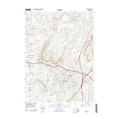
2015 Map of Meriden
USGS Topo · Published 2015About this map
The Hanging Hills and the prominent Metacomet Ridge dominate this central Connecticut landscape, creating a dramatic corridor for the Quinnipiac River and its associated Quinnipiac Gorge. In the city of Meriden, the built environment is densely packed around historical centers like East Meriden and South Meriden, reflecting the area's industrial legacy. Genealogists will find a wealth of burial sites, ranging from the colonial-era Burying Ground 1720 to the Meriden Hebrew Cem and Gethsemane Cem. The map illustrates the region's complex water management system, featuring numerous reservoirs like Hallmere Reservoir and Kenmere Reservoir, alongside recreational landmarks such as Dossin Park Beach on Hanover Pond. Transportation routes follow the natural topography, with the New England National Scenic Trail traversing the heights of Lamentation Mtn and Cathole Mtn, while the Meriden Markham Municipal Airport occupies the flatter land to the south near Tracy.
Find a feature on this map
89 named features on this map. Tap any name to fly to it.
Don’t see what you’re looking for? This feature index may not catch every label — zoom into the map to look around manually.
Map Details
Editions of this 2015 Meriden Map
This is the sole edition of this map. No revisions or reprints were ever made.
Other maps of this area

1892 · New Haven
USGS Topo · 1:62,500

1892 · Meriden
USGS Topo · 1:62,500

1893 · Guilford
USGS Topo · 1:62,500

1893 · Middletown
USGS Topo · 1:62,500

1893 · Meriden
USGS Topo · 1:62,500

1906 · Farmington
USGS Topo · 1:125,000

1921 · New Haven
USGS Topo · 1:62,500

1928 · Cromwell
USGS Topo · 1:24,000

1943 · Durham
USGS Topo · 1:25,000

1944 · Hartford South
USGS Topo · 1:31,680