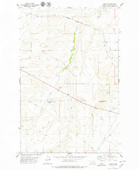
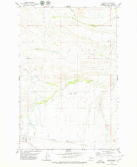
1978 Map of Merino
USGS Topo · Published 1979About this map
The Surprise Creek Colony is a central feature of this central Montana landscape, situated near the North Fork Surprise Creek and its associated Cem. The map reveals a transition between the irrigated creek bottoms and the higher prairie terrain, where seasonal drainages like Fox Coulee and Sun Creek mark the dry land. Transportation in this part of Judith Basin County was defined by the Burlington Northern railroad, which navigates the northern hills through a notable Tunnel. Small settlement points like Merino and Dover anchor the high plains, while a network of springs and gravel pits suggests a rural economy tied closely to the land's geology and water resources. The detailed topography illustrates the elevation changes from the rolling flats to the distinct rise of Antelope Butte in the southeast.
Find a feature on this map
18 named features on this map. Tap any name to fly to it.
Don’t see what you’re looking for? This feature index may not catch every label — zoom into the map to look around manually.
Map Details
Editions of this 1978 Merino Map
This is the sole edition of this map. No revisions or reprints were ever made.
Other maps of this area

1890 · Fort Benton
USGS Topo · 1:250,000

1892 · Fort Benton
USGS Topo · 1:250,000

1897 · Fort Benton
USGS Topo · 1:250,000

1954 · Great Falls
USGS Topo · 1:250,000

1957 · Great Falls
USGS Topo · 1:250,000

1978 · Leiberg Coulee
USGS Topo · 1:24,000
1978 · Windham
USGS Topo · 1:24,000
1978 · Stanford
USGS Topo · 1:24,000
1979 · Cayuse Basin
USGS Topo · 1:24,000
1979 · Geyser
USGS Topo · 1:24,000