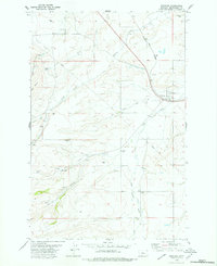
1978 Map of Windham
USGS Topo · Published 1979About this map
Windham serves as the primary hub in this Judith Basin County landscape, situated where the Burlington Northern line cuts through the prairie. The map reveals a distinct history of extraction and industry, particularly in the southern reaches near the North Fork of Willow Creek. Here, the settlement of Lehigh and the nearby cluster at Scholztown are surrounded by numerous Mines and Prospects, documenting the region’s coal mining legacy. The Lehigh Cem remains a quiet landmark of these former mining communities.
Find a feature on this map
28 named features on this map. Tap any name to fly to it.
Don’t see what you’re looking for? This feature index may not catch every label — zoom into the map to look around manually.
Map Details
Editions of this 1978 Windham Map
This is the sole edition of this map. No revisions or reprints were ever made.
Other maps of this area

1886 · Little Belt Mts.
USGS Topo · 1:250,000

1890 · Fort Benton
USGS Topo · 1:250,000

1892 · Fort Benton
USGS Topo · 1:250,000

1894 · Little Belt Mts.
USGS Topo · 1:250,000

1897 · Fort Benton
USGS Topo · 1:250,000

1897 · Little Belt Mts.
USGS Topo · 1:250,000

1898 · Little Belt Mts.
USGS Topo · 1:250,000

1902 · Little Belt Mts.
USGS Topo · 1:250,000

1948 · White Sulphur Springs
USGS Topo · 1:250,000

1954 · Great Falls
USGS Topo · 1:250,000