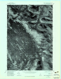
1977 Map of Merrill Mountain
USGS Topo · Published 1983About this map
Merrill Mountain and Vane Mountain dominate this late 1970s orthophotoquad, which captures the dense timberlands and hydrologic patterns of the Maine-Quebec border region. Prepared from aerial photography taken in late 1977, the imagery reveals the complex drainage of the Riviere Aux Araignees as it flows through the western portion of the quadrangle. The map highlights the rugged topography of Franklin County where the West Branch Moose R and Number One Brook carve through the forested landscape. Researchers of this remote international boundary will find significant detail in the wetland formations, such as the Lower Hathan Bog, providing a clear look at the terrain before contemporary changes in forest management and land use altered the local character.
Find a feature on this map
6 named features on this map. Tap any name to fly to it.
Don’t see what you’re looking for? This feature index may not catch every label — zoom into the map to look around manually.
Map Details
Editions of this 1977 Merrill Mountain Map
This is the sole edition of this map. No revisions or reprints were ever made.
Other maps of this area

1928 · Chain Lakes
USGS Topo · 1:48,000

1928 · Skinner
USGS Topo · 1:48,000

1931 · Skinner
USGS Topo · 1:62,500

1932 · Arnold Pond
USGS Topo · 1:48,000

1932 · Chain Lakes
USGS Topo · 1:62,500

1935 · Chain Lakes
USGS Topo · 1:62,500

1935 · Arnold Pond
USGS Topo · 1:62,500

1949 · Jackman
USGS Topo · 1:250,000
1951 · Chain Lakes
USGS Topo · 1:50,000

1963 · Jackman
USGS Topo · 1:250,000