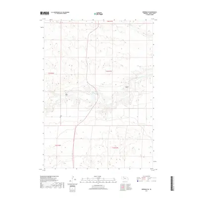
2017 Map of Merriman SW
USGS Topo · Published 2017About this map
The Niobrara River carves a winding path through this portion of Cherry County, defining the central landscape with its braided channels and riparian banks. Significant for local transit, the Madison Bridge and Rockford Bridge provide essential crossing points over the river, linking the northern and southern plateaus of the Nebraska Sandhills. North of the river, the smaller Leander Cr drains the undulating hills, while further south, the Center Cem serves as a quiet landmark for family historians and genealogists. This 2017 survey reflects a sparsely populated ranching environment where the terrain is dominated by traditional land partitions, including the intersection of multiple township boundaries such as t33n r37w and t32n r37w.
Find a feature on this map
10 named features on this map. Tap any name to fly to it.
Don’t see what you’re looking for? This feature index may not catch every label — zoom into the map to look around manually.
Map Details
Editions of this 2017 Merriman SW Map
This is the sole edition of this map. No revisions or reprints were ever made.
Other maps of this area

1950 · Irwin
USGS Topo · 1:62,500

1951 · Irwin
USGS Topo · 1:62,500

1951 · Gypsy Valley
USGS Topo · 1:62,500

1951 · Merriman
USGS Topo · 1:62,500

1951 · Merriman 4
USGS Topo · 1:62,500

1957 · Valentine
USGS Topo · 1:250,000

1959 · Valentine
USGS Topo · 1:250,000

1985 · Cody
USGS Topo · 1:100,000
1990 · Merriman NE
USGS Topo · 1:24,000
1990 · Merriman
USGS Topo · 1:24,000