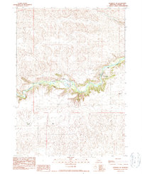
1990 Map of Merriman SW
USGS Topo · Published 1990About this map
The Niobrara River carves a deep, winding path through the center of this terrain, creating a sharp contrast between the river valley and the surrounding Nebraska sandhills. This 1990 provisional survey records the isolated ranching outposts that define the local landscape, including the Cobb Ranch and Shadbolts Ranch situated along the northern bluffs. Crossing points like the Madison Bridge and Rockford Bridge provide essential links across the water, anchoring the sparse road network.
Find a feature on this map
12 named features on this map. Tap any name to fly to it.
Don’t see what you’re looking for? This feature index may not catch every label — zoom into the map to look around manually.
Map Details
Editions of this 1990 Merriman SW Map
This is the sole edition of this map. No revisions or reprints were ever made.
Other maps of this area

1950 · Irwin
USGS Topo · 1:62,500

1951 · Irwin
USGS Topo · 1:62,500

1951 · Gypsy Valley
USGS Topo · 1:62,500

1951 · Merriman
USGS Topo · 1:62,500

1951 · Merriman 4
USGS Topo · 1:62,500

1957 · Valentine
USGS Topo · 1:250,000

1959 · Valentine
USGS Topo · 1:250,000

1985 · Cody
USGS Topo · 1:100,000
1990 · Merriman NE
USGS Topo · 1:24,000
1990 · Merriman
USGS Topo · 1:24,000