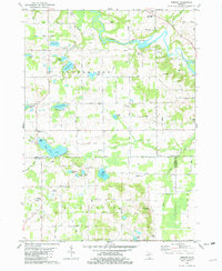
1981 Map of Merson
USGS Topo · Published 1982About this map
The Kalamazoo River winds through the northern portion of this landscape, its flow managed by the Trowbridge Dam. This region along the Allegan and Van Buren county line is defined by its numerous water bodies and glacial depressions, including Pike Lake, Lake Sixteen, and Base Line Lake. Settlement is concentrated around the small community of Merson and scattered agricultural holdings connected by a grid of namesake avenues. Local history is anchored by sites like Trowbridge Ch, the Gobles Junior Academy, and several family-named burial grounds such as Blackman Cem and Mallory Cem. The land use shows a mix of recreation and industry, with the Timber Ridge Ski Area and Har-Lou Golf Course situated near active Oil Wells and numerous Gravel Pits, reflecting the diverse economic character of the rural townships in the early 1980s.
Find a feature on this map
57 named features on this map. Tap any name to fly to it.
Don’t see what you’re looking for? This feature index may not catch every label — zoom into the map to look around manually.
Map Details
Editions of this 1981 Merson Map
This is the sole edition of this map. No revisions or reprints were ever made.
Other maps of this area

1916 · Kalamazoo
USGS Topo · 1:62,500

1918 · Kalamazoo
USGS Topo · 1:62,500

1943 · Kalamazoo
USGS Topo · 1:62,500

1946 · Gobles
USGS Topo · 1:62,500

1948 · Gobles
USGS Topo · 1:62,500

1949 · Gobles
USGS Topo · 1:62,500

1958 · Allegan
USGS Topo · 1:62,500

1958 · Grand Rapids
USGS Topo · 1:250,000

1959 · Wayland
USGS Topo · 1:62,500

1961 · Grand Rapids
USGS Topo · 1:250,000