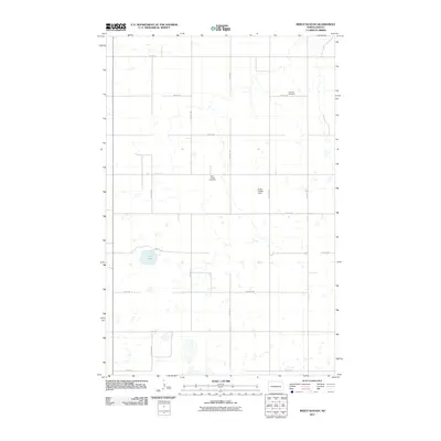
2011 Map of Mertz Slough
USGS Topo · Published 2011About this map
Saint James Cemetery and Fairview Cemetery stand as quiet landmarks within this rural Sheridan County landscape, reflecting the heritage of early North Dakota families. The terrain is defined by a grid-like network of country roads, including 15th Ave NE and 14th St NE, which segment the prairie into large agricultural blocks. Pockets of water, most notably Jones Lake, dot the landscape between these thoroughfares. Unique local features such as the Frueh Private Field provide insight into modern private land use and aviation within this prairie setting. This 2011 survey records the region's enduring character as an agricultural heartland, where the spatial arrangement of cemeteries and farm-to-market roads preserves the lineage of the local community.
Find a feature on this map
19 named features on this map. Tap any name to fly to it.
Don’t see what you’re looking for? This feature index may not catch every label — zoom into the map to look around manually.
Map Details
Editions of this 2011 Mertz Slough Map
This is the sole edition of this map. No revisions or reprints were ever made.
Other maps of this area

1946 · Sheyenne Lake
USGS Topo · 1:48,000

1947 · Lincoln Valley
USGS Topo · 1:62,500

1947 · Sheyenne Lake
USGS Topo · 1:62,500

1950 · Sheyenne Lake NE
USGS Topo · 1:24,000

1950 · Sheyenne Lake
USGS Topo · 1:24,000

1954 · McClusky
USGS Topo · 1:250,000

1958 · McClusky
USGS Topo · 1:250,000

1960 · Lincoln Valley SE
USGS Topo · 1:24,000

1960 · Denhoff
USGS Topo · 1:24,000
1960 · Lincoln Valley
USGS Topo · 1:24,000