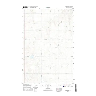
2014 Map of Mertz Slough
USGS Topo · Published 2014About this map
Fairview Cem and Saint James Cem sit amidst a vast, undulating grid of section lines in this Sheridan County landscape. The terrain is defined by its glacial prairie potholes and seasonal water bodies, most notably the blue expanse of Jones Lake in the western portion of the quadrangle. This 2014 survey by the U.S. Geological Survey illustrates the rigid township and range organization that governs the Dakotas, where a network of gravel roads including 14th St NE and 15th Ave NE provides the primary access to isolated agricultural plots. The map records the persistence of small rural burial grounds as the primary landmarks in an area otherwise characterized by expansive fields and natural drainage basins.
Find a feature on this map
17 named features on this map. Tap any name to fly to it.
Don’t see what you’re looking for? This feature index may not catch every label — zoom into the map to look around manually.
Map Details
Editions of this 2014 Mertz Slough Map
This is the sole edition of this map. No revisions or reprints were ever made.
Other maps of this area

1946 · Sheyenne Lake
USGS Topo · 1:48,000

1947 · Lincoln Valley
USGS Topo · 1:62,500

1947 · Sheyenne Lake
USGS Topo · 1:62,500

1950 · Sheyenne Lake NE
USGS Topo · 1:24,000

1950 · Sheyenne Lake
USGS Topo · 1:24,000

1954 · McClusky
USGS Topo · 1:250,000

1958 · McClusky
USGS Topo · 1:250,000

1960 · Lincoln Valley SE
USGS Topo · 1:24,000

1960 · Denhoff
USGS Topo · 1:24,000
1960 · Lincoln Valley
USGS Topo · 1:24,000