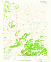
1963 Map of Mesa De Los Toros
USGS Topo · Published 1966About this map
Continental Divide winds through this high-altitude landscape of McKinley County, defining a rugged New Mexico environment of mesas and deep canyons as it appeared in the mid-1960s. The topography is dominated by massive elevated formations like Mesa de los Toros and Mesa Amada, which overlook a complex drainage system including Cañada Marcelina and Cañon Largo. Human presence in this arid region is marked by isolated outposts and livestock infrastructure, such as Albert Ranch and Rancho Nuevo. Water sources were critical to life here, evidenced by the scattered distribution of sites like Inditoe Camp Well, Milpitas Well, and the curiously named Grandmas Swimming Pool. This survey documents a traditional ranching landscape where names like Atarque de Marcelina suggest the long-standing Hispanic heritage of local land use and water management.
Find a feature on this map
35 named features on this map. Tap any name to fly to it.
Don’t see what you’re looking for? This feature index may not catch every label — zoom into the map to look around manually.
Map Details
Editions of this 1963 Mesa De Los Toros Map
This is the sole edition of this map. No revisions or reprints were ever made.
Other maps of this area

1883 · Mt. Taylor
USGS Topo · 1:250,000

1886 · Mt. Taylor
USGS Topo · 1:250,000

1892 · Mt. Taylor
USGS Topo · 1:250,000

1899 · Mt. Taylor
USGS Topo · 1:250,000

1957 · Ambrosia Lake
USGS Topo · 1:24,000

1957 · Goat Mountain
USGS Topo · 1:24,000

1958 · Albuquerque
USGS Topo · 1:250,000

1961 · Piedra De La Aguila
USGS Topo · 1:24,000

1961 · Hospah
USGS Topo · 1:24,000

1962 · Albuquerque
USGS Topo · 1:250,000