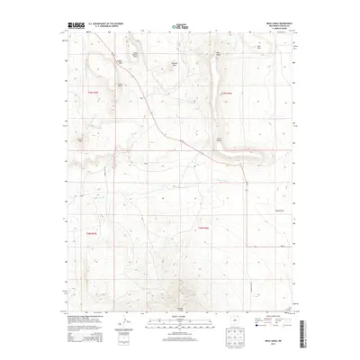
2013 Map of Mesa Larga
USGS Topo · Published 2013About this map
Laughlin Peak dominates the southern reaches of this landscape, rising above a network of mesa-and-arroyo terrain in Colfax County. This 2013 survey illustrates a high-desert environment where drainage patterns like Green Mountain Arroyo and Blosser Arroyo cut through the prominent tablelands of Mesa Larga, Troyburg Mesa, and Loco Mesa. The human footprint is sparse but specific, defined by small settlements such as Aragon, Cunico, and Hennegan. Transportation is anchored by the winding path of NM-193, which serves as the primary artery connecting these high-altitude locales. Local land use is further evidenced by secondary routes like Moore Camp Rd and Laughlin Peak Rd, reflecting a landscape geared toward ranching or resource management amidst the dramatic topographic features of Nipple Peak and Round Mesa.
Find a feature on this map
25 named features on this map. Tap any name to fly to it.
Don’t see what you’re looking for? This feature index may not catch every label — zoom into the map to look around manually.
Map Details
Editions of this 2013 Mesa Larga Map
This is the sole edition of this map. No revisions or reprints were ever made.
Other maps of this area

1912 · Raton
USGS Topo · 1:62,500

1914 · Raton
USGS Topo · 1:62,500

1954 · Raton
USGS Topo · 1:250,000

1958 · Raton
USGS Topo · 1:250,000

1971 · Kiowa
USGS Topo · 1:24,000

1971 · Tres Hermanos Peak
USGS Topo · 1:24,000
1971 · Hunter Mesa
USGS Topo · 1:24,000

1971 · Robinson Peak
USGS Topo · 1:24,000

1971 · Johnson Park
USGS Topo · 1:24,000

1971 · Pine Buttes
USGS Topo · 1:24,000