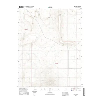
2017 Map of Mesa Larga
USGS Topo · Published 2017About this map
Laughlin Peak dominates the southern reaches of this Colfax County landscape, serving as a prominent landmark in a region defined by high tablelands and deeply cut drainages. The topography is characterized by a series of distinct elevations, including the broad Mesa Larga and the sharper profiles of Nipple Peak and Round Mesa. These features illustrate the erosion patterns of the high plains, where the land drops away into Cedar Canyon or levels out into the Kiowa Flats.
Find a feature on this map
22 named features on this map. Tap any name to fly to it.
Don’t see what you’re looking for? This feature index may not catch every label — zoom into the map to look around manually.
Map Details
Editions of this 2017 Mesa Larga Map
This is the sole edition of this map. No revisions or reprints were ever made.
Other maps of this area

1912 · Raton
USGS Topo · 1:62,500

1914 · Raton
USGS Topo · 1:62,500

1954 · Raton
USGS Topo · 1:250,000

1958 · Raton
USGS Topo · 1:250,000

1971 · Kiowa
USGS Topo · 1:24,000

1971 · Tres Hermanos Peak
USGS Topo · 1:24,000
1971 · Hunter Mesa
USGS Topo · 1:24,000

1971 · Robinson Peak
USGS Topo · 1:24,000

1971 · Johnson Park
USGS Topo · 1:24,000

1971 · Pine Buttes
USGS Topo · 1:24,000