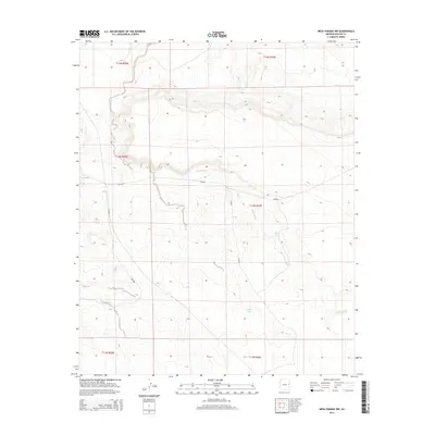
2014 Map of Mesa Parada NW
USGS Topo · Published 2014About this map
Jarvis Wash winds through this arid portion of Apache County, serving as the primary drainage for a landscape defined by significant elevation changes. This region of northeastern Arizona is marked by its isolation and reliance on critical water resources such as Coulter Tank and Upper Tank, which are vital landmarks in an otherwise dry terrain. The map details the rural infrastructure of the early 21st century, including Cr-6040 and Cr-6001, providing a clear record of the access roads used by local ranchers and land managers. This documentation of the Public Land Survey System boundaries, including t12n r30e and t13n r30e, reflects the orderly division of the high desert plateau.
Find a feature on this map
11 named features on this map. Tap any name to fly to it.
Don’t see what you’re looking for? This feature index may not catch every label — zoom into the map to look around manually.
Map Details
Editions of this 2014 Mesa Parada NW Map
This is the sole edition of this map. No revisions or reprints were ever made.
Other maps of this area

1886 · St Johns
USGS Topo · 1:250,000

1892 · St Johns
USGS Topo · 1:250,000

1954 · Saint Johns
USGS Topo · 1:250,000

1957 · Saint Johns
USGS Topo · 1:250,000

1958 · Saint Johns
USGS Topo · 1:250,000

1962 · Saint Johns
USGS Topo · 1:250,000

1971 · Mesa Parada NW
USGS Topo · 1:24,000

1971 · Mesa Parada
USGS Topo · 1:24,000
1971 · Voigt Ranch
USGS Topo · 1:24,000
1971 · The Rincon
USGS Topo · 1:24,000