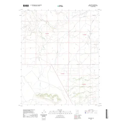
2023 Map of Mesa Pino
USGS Topo · Published 2023About this map
Mesa Pino stands as the dominant landform in this section of San Miguel County, anchoring a landscape defined by an intricate network of drainage systems. The northern reaches are shaped by the Conchas River, which is joined by Corazon Creek and several numbered tributaries like Creek C-58-C. The central and southern portions of the sheet are marked by the winding paths of El Poso Creek and Garita Creek, illustrating a classic high-desert watershed pattern where seasonal flow has carved distinct paths through the terrain.
Find a feature on this map
14 named features on this map. Tap any name to fly to it.
Don’t see what you’re looking for? This feature index may not catch every label — zoom into the map to look around manually.
Map Details
Editions of this 2023 Mesa Pino Map
This is the sole edition of this map. No revisions or reprints were ever made.
Other maps of this area

1892 · Corazon
USGS Topo · 1:125,000

1894 · Corazon
USGS Topo · 1:125,000

1954 · Santa Fe
USGS Topo · 1:250,000

1958 · Santa Fe
USGS Topo · 1:250,000

1963 · Mesa Cherisco
USGS Topo · 1:24,000
1963 · Bar Y Ranch
USGS Topo · 1:24,000

1963 · Mesita Del Gato
USGS Topo · 1:24,000

1972 · Variadero
USGS Topo · 1:24,000

1972 · La Silla
USGS Topo · 1:24,000
1972 · Cabra Hill
USGS Topo · 1:24,000