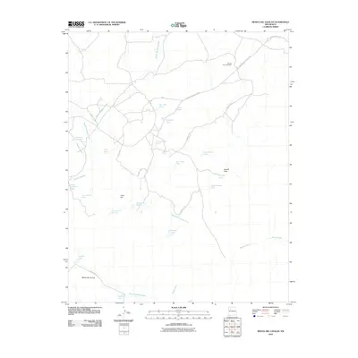
2010 Map of Mesita Del Gavilan
USGS Topo · Published 2010About this map
Rancho Rincon Marquez stands as a focal point of settlement in this arid McKinley County landscape, where the distribution of water sources dictates the geography of human activity. The terrain is defined by the prominent Mesita del Gavilan and distinctive geological features like Cone Hill and Pagoda Rock. A complex network of ephemeral drainage systems, including the Rincon Marquez Arroyo and North Fork Arroyo Chico, carves through the region, supported by numerous man-made water catchments such as Martinez Tank, Stockade Tank, and Indian Pond. Connectivity across these high-desert plains is maintained by dedicated transit corridors, specifically Indian Service Route 7028 and Navajo Service Route 7004. These routes, alongside County Rd-19, provide a window into the jurisdictional and logistical patterns of this part of New Mexico in the early 21st century.
Find a feature on this map
30 named features on this map. Tap any name to fly to it.
Don’t see what you’re looking for? This feature index may not catch every label — zoom into the map to look around manually.
Map Details
Editions of this 2010 Mesita Del Gavilan Map
This is the sole edition of this map. No revisions or reprints were ever made.
Other maps of this area

1883 · Mt. Taylor
USGS Topo · 1:250,000

1886 · Mt. Taylor
USGS Topo · 1:250,000

1892 · Mt. Taylor
USGS Topo · 1:250,000

1899 · Mt. Taylor
USGS Topo · 1:250,000

1958 · Albuquerque
USGS Topo · 1:250,000

1961 · El Dado
USGS Topo · 1:24,000

1961 · Whitehorse Rincon
USGS Topo · 1:24,000

1961 · Cerro Parido
USGS Topo · 1:24,000

1961 · Mesita Del Gavilan
USGS Topo · 1:24,000
1961 · Mesita Americana
USGS Topo · 1:24,000