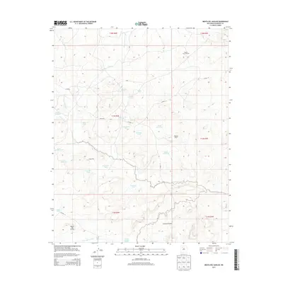
2013 Map of Mesita Del Gavilan
USGS Topo · Published 2013About this map
Rancho Rincon Marquez stands as the primary namesake settlement in this northern New Mexico landscape, situated amidst a complex network of drainage basins and high mesas. The terrain is defined by the significant passage of Rincon Marquez Arroyo and the southern Arroyo Chico, which collect runoff from various canyons and draws. This high-desert environment is marked by numerous water management features essential for ranching, including named cattle tanks like Martinez Tank, Indian Pond, and Steamboat Tank.
Find a feature on this map
38 named features on this map. Tap any name to fly to it.
Don’t see what you’re looking for? This feature index may not catch every label — zoom into the map to look around manually.
Map Details
Editions of this 2013 Mesita Del Gavilan Map
This is the sole edition of this map. No revisions or reprints were ever made.
Other maps of this area

1883 · Mt. Taylor
USGS Topo · 1:250,000

1886 · Mt. Taylor
USGS Topo · 1:250,000

1892 · Mt. Taylor
USGS Topo · 1:250,000

1899 · Mt. Taylor
USGS Topo · 1:250,000

1958 · Albuquerque
USGS Topo · 1:250,000

1961 · El Dado
USGS Topo · 1:24,000

1961 · Whitehorse Rincon
USGS Topo · 1:24,000

1961 · Cerro Parido
USGS Topo · 1:24,000

1961 · Mesita Del Gavilan
USGS Topo · 1:24,000
1961 · Mesita Americana
USGS Topo · 1:24,000