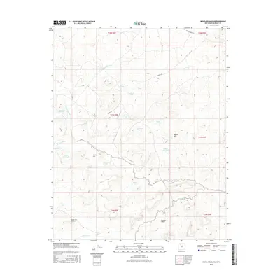
2017 Map of Mesita Del Gavilan
USGS Topo · Published 2017About this map
Mesita del Gavilan sits at the heart of this high-desert landscape in McKinley County, where the terrain is defined by a dense network of seasonal water management features and named arroyos. The land is intricately carved by Arroyo Chico and its tributaries, including the North Fork Arroyo Chico and Arroyo Lucero. This region relied heavily on scattered water sources such as Indian Pond, Amos Pit Reservoir, and numerous named livestock tanks like Martinez Tank and Alvario Tank. Prominent landmarks such as Cone Hill and Pagoda Rock provide navigational anchors across the open range. The presence of Hospah Rd and Rincon Marquez Rd indicates the vital transit corridors that connect this isolated cattle country to the broader New Mexico hinterland, while Carreton Canyon reveals the dramatic elevation changes characteristic of the Colorado Plateau.
Find a feature on this map
36 named features on this map. Tap any name to fly to it.
Don’t see what you’re looking for? This feature index may not catch every label — zoom into the map to look around manually.
Map Details
Editions of this 2017 Mesita Del Gavilan Map
This is the sole edition of this map. No revisions or reprints were ever made.
Other maps of this area

1883 · Mt. Taylor
USGS Topo · 1:250,000

1886 · Mt. Taylor
USGS Topo · 1:250,000

1892 · Mt. Taylor
USGS Topo · 1:250,000

1899 · Mt. Taylor
USGS Topo · 1:250,000

1958 · Albuquerque
USGS Topo · 1:250,000

1961 · El Dado
USGS Topo · 1:24,000

1961 · Whitehorse Rincon
USGS Topo · 1:24,000

1961 · Cerro Parido
USGS Topo · 1:24,000

1961 · Mesita Del Gavilan
USGS Topo · 1:24,000
1961 · Mesita Americana
USGS Topo · 1:24,000