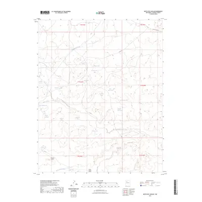
2023 Map of Mesita Del Gavilan
USGS Topo · Published 2023About this map
Mesita del Gavilan rises as the central topographic feature in this arid landscape, which is defined by an intricate network of ephemeral water drainage systems and artificial stock tanks. The hydrologic pattern across this portion of McKinley County is dominated by the North Fork Arroyo Chico and the Rincon Marquez Arroyo, while smaller drainages like Arroyo Lucero and Arroyo Calladito carve through the high desert terrain. The distribution of family-named water features, such as Arroyo Alfredo Padilla, Martinez Tank, and Alvario Tank, suggests a history of grazing and ranching operations dependent on these localized water sources. Transportation is limited to rugged routes like Hospah Rd and Co Rd 19, which connect distant points across the basin. Other notable landmarks including Castle Rock Tank and Indian Pond serve as critical navigational and resource points in this open, sparsely populated region.
Find a feature on this map
32 named features on this map. Tap any name to fly to it.
Don’t see what you’re looking for? This feature index may not catch every label — zoom into the map to look around manually.
Map Details
Editions of this 2023 Mesita Del Gavilan Map
This is the sole edition of this map. No revisions or reprints were ever made.
Other maps of this area

1883 · Mt. Taylor
USGS Topo · 1:250,000

1886 · Mt. Taylor
USGS Topo · 1:250,000

1892 · Mt. Taylor
USGS Topo · 1:250,000

1899 · Mt. Taylor
USGS Topo · 1:250,000

1958 · Albuquerque
USGS Topo · 1:250,000

1961 · El Dado
USGS Topo · 1:24,000

1961 · Whitehorse Rincon
USGS Topo · 1:24,000

1961 · Cerro Parido
USGS Topo · 1:24,000

1961 · Mesita Del Gavilan
USGS Topo · 1:24,000
1961 · Mesita Americana
USGS Topo · 1:24,000