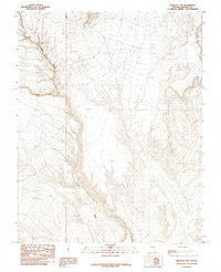
1985 Map of Mesquite NW
USGS Topo · Published 1985About this map
Tule Springs Hills dominate the northern landscape of this Lincoln County terrain, where the arid environment is defined by complex drainage systems rather than permanent settlements. The Toquop Wash serves as the primary topographic artery, cutting a deep path southward through the desert floor. This 1985 provisional edition reveals the intricate contouring of the region's alluvial fans and the confluence where the South Fork joins the main wash. The presence of Tule Springs at the foot of the hills suggests a vital water source in an otherwise dry expanse, a critical landmark for those tracing the historical movement of people and livestock through the eastern Nevada desert. The map illustrates a landscape shaped by seasonal water flow and geological transition, captured during a period of detailed field checking in the late 1970s.
Find a feature on this map
5 named features on this map. Tap any name to fly to it.
Don’t see what you’re looking for? This feature index may not catch every label — zoom into the map to look around manually.
Map Details
Editions of this 1985 Mesquite NW Map
This is the sole edition of this map. No revisions or reprints were ever made.
Other maps of this area

1885 · Pioche
USGS Topo · 1:250,000

1886 · Saint Thomas
USGS Topo · 1:250,000

1886 · Pioche
USGS Topo · 1:250,000

1893 · Saint Thomas
USGS Topo · 1:250,000

1954 · Caliente
USGS Topo · 1:250,000

1954 · Las Vegas
USGS Topo · 1:250,000

1957 · Las Vegas
USGS Topo · 1:250,000

1957 · Mesquite
USGS Topo · 1:62,500

1959 · Caliente
USGS Topo · 1:250,000

1959 · Las Vegas
USGS Topo · 1:250,000