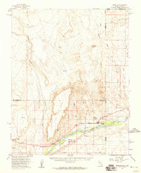
1957 Map of Mesquite
USGS Topo · Published 1959About this map
The Virgin River valley serves as the lifeblood of this desert landscape, where the settlements of Mesquite and Bunkerville are established along its fertile banks. This mid-century survey captures a period of transition as the region's agricultural roots began to intersect with modern infrastructure. The presence of Route 91 and a local Airport indicates the growing connectivity of this corner of Nevada, even as the surrounding terrain remains dominated by formidable geological features like Flat Top Mesa and Lone Mesa. Extensive drainage networks, including Toquop, Beaver Dam Wash, and Sand Hollow Wash, illustrate the complex hydrology that shaped the development of these isolated communities. To the north and west, the map details the high Mesa country, providing a clear record of the surveying points and reservoirs essential for managing water in the Virgin Valley during the late 1950s.
Find a feature on this map
24 named features on this map. Tap any name to fly to it.
Don’t see what you’re looking for? This feature index may not catch every label — zoom into the map to look around manually.
Map Details
Editions of this 1957 Mesquite Map
2 editions found
Other maps of this area

1885 · St. George
USGS Topo · 1:250,000

1885 · Pioche
USGS Topo · 1:250,000

1886 · Saint Thomas
USGS Topo · 1:250,000

1886 · Mt. Trumbull
USGS Topo · 1:250,000

1886 · Pioche
USGS Topo · 1:250,000

1891 · St. George
USGS Topo · 1:250,000

1892 · Mt. Trumbull
USGS Topo · 1:250,000

1893 · Saint Thomas
USGS Topo · 1:250,000

1953 · Cedar City
USGS Topo · 1:250,000

1953 · Grand Canyon
USGS Topo · 1:250,000