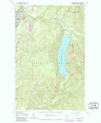
1967 Map of Metaline Falls
USGS Topo · Published 1986About this map
Metaline Falls serves as the industrial and civic heart of this northeastern Washington landscape, where the Pend Oreille River cuts through the mountains. The town's economic reliance on mining and timber is visible through the Grandview Mine and a distinctive Aerial Tramway near the riverbanks. An Elevated Aqueduct follows the course of Sullivan Creek, signaling the complex infrastructure required to manage water resources in this steep terrain.
Find a feature on this map
42 named features on this map. Tap any name to fly to it.
Don’t see what you’re looking for? This feature index may not catch every label — zoom into the map to look around manually.
Map Details
Editions of this 1967 Metaline Falls Map
3 editions found
Other maps of this area

1934 · Metaline
USGS Topo · 1:125,000

1942 · Metaline
USGS Topo · 1:125,000

1958 · Sandpoint
USGS Topo · 1:250,000

1963 · Sandpoint
USGS Topo · 1:250,000

1967 · Gypsy Peak
USGS Topo · 1:24,000

1967 · Ione
USGS Topo · 1:24,000

1967 · Scotchman Lake
USGS Topo · 1:24,000

1967 · Boundary Dam
USGS Topo · 1:24,000

1967 · Metaline
USGS Topo · 1:24,000

1967 · Metaline Falls
USGS Topo · 1:24,000