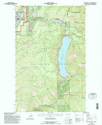
1992 Map of Metaline Falls
USGS Topo · Published 1996About this map
Metaline Falls serves as the industrial and civic anchor for this mountain landscape along the Pend Oreille River during the early 1990s. The map illustrates a complex local economy where mining, power generation, and recreation intersect. An Aerial Tramway and the nearby Grandview Mine highlight the area's extraction history, while a Powerplant and multiple Gaging Stations track the utility of the river. To the east, the terrain transitions into the protected Colville National Forest and Salmo-Priest Wilderness. Significant water features like Sullivan Lake and Mill Pond dominate the central topography, supported by infrastructure such as a Landing Strip and Boat Ramp. For genealogists and local historians, the IOOF Cem and the settlement of Pend Oreille Village offer specific points of interest for tracing family roots in this corner of Washington.
Find a feature on this map
37 named features on this map. Tap any name to fly to it.
Don’t see what you’re looking for? This feature index may not catch every label — zoom into the map to look around manually.
Map Details
Editions of this 1992 Metaline Falls Map
This is the sole edition of this map. No revisions or reprints were ever made.
Other maps of this area

1934 · Metaline
USGS Topo · 1:125,000

1942 · Metaline
USGS Topo · 1:125,000

1958 · Sandpoint
USGS Topo · 1:250,000

1963 · Sandpoint
USGS Topo · 1:250,000

1967 · Gypsy Peak
USGS Topo · 1:24,000

1967 · Ione
USGS Topo · 1:24,000

1967 · Scotchman Lake
USGS Topo · 1:24,000

1967 · Boundary Dam
USGS Topo · 1:24,000

1967 · Metaline
USGS Topo · 1:24,000

1967 · Metaline Falls
USGS Topo · 1:24,000