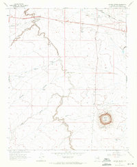
1968 Map of Meteor Crater
USGS Topo · Published 1971About this map
Meteor Crater dominates the southeastern quadrant of this high-desert landscape, located just south of the Atchison Topeka and Santa Fe railroad line. The map records a fascinating intersection of geological wonder and Route 66-era roadside history. The settlement of Two Guns sits perched at the crossing of Canyon Diablo and Wagon Box Draw, where several ruins are noted. Further east along the highway, the stop at Rimmy Jims provides another focal point for travel and commerce in this arid Coconino County terrain.
Find a feature on this map
28 named features on this map. Tap any name to fly to it.
Don’t see what you’re looking for? This feature index may not catch every label — zoom into the map to look around manually.
Map Details
Editions of this 1968 Meteor Crater Map
3 editions found
Other maps of this area

1883 · Tusayan
USGS Topo · 1:250,000

1886 · Tusayan
USGS Topo · 1:250,000

1886 · San Francisco Mtns
USGS Topo · 1:250,000

1886 · Holbrook
USGS Topo · 1:250,000

1887 · Verde
USGS Topo · 1:250,000

1891 · San Francisco Mtns
USGS Topo · 1:250,000

1892 · Verde
USGS Topo · 1:250,000

1893 · Holbrook
USGS Topo · 1:250,000

1894 · San Francisco Mtns
USGS Topo · 1:250,000

1899 · San Francisco Mtns
USGS Topo · 1:250,000