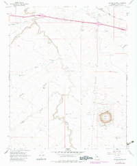
1968 Map of Meteor Crater
USGS Topo · Published 1983About this map
Meteor Crater dominates the southeastern portion of this Coconino County survey, where a Museum and nearby Sandpits mark the site of this major geologic feature. The winding course of Canyon Diablo carves through the high desert landscape, intersected by the Atchison Topeka and Santa Fe railroad in the north. This rail corridor supports the small settlement of Sunshine, situated near Radio Facilities and a substation that speak to the mid-century infrastructure of the region.
Find a feature on this map
28 named features on this map. Tap any name to fly to it.
Don’t see what you’re looking for? This feature index may not catch every label — zoom into the map to look around manually.
Map Details
Editions of this 1968 Meteor Crater Map
3 editions found
Other maps of this area

1883 · Tusayan
USGS Topo · 1:250,000

1886 · Tusayan
USGS Topo · 1:250,000

1886 · San Francisco Mtns
USGS Topo · 1:250,000

1886 · Holbrook
USGS Topo · 1:250,000

1887 · Verde
USGS Topo · 1:250,000

1891 · San Francisco Mtns
USGS Topo · 1:250,000

1892 · Verde
USGS Topo · 1:250,000

1893 · Holbrook
USGS Topo · 1:250,000

1894 · San Francisco Mtns
USGS Topo · 1:250,000

1899 · San Francisco Mtns
USGS Topo · 1:250,000