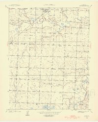
1938 Map of Metz
USGS Topo · Published 1954About this map
The Little Osage River and the Marmaton River define the hydraulic character of this Vernon County landscape, which was surveyed in the late 1930s. The town of Metz serves as the primary northern hub, situated near the Pacific railroad line and a complex of local schools including Old Metz Sch. Rural life at this time was anchored by a network of one-room schoolhouses and country churches, such as Roundtop Sch, Whittfield Sch, and the Otterbein Chapel. Along the river bottoms, family and community history is preserved in several burial sites including Pryor Creek Cem and Summers Cem. Notable water crossings like Dean Ford on the Marmaton River indicate how residents navigated the seasonal waterways before modern bridge infrastructure dominated the region.
Find a feature on this map
34 named features on this map. Tap any name to fly to it.
Don’t see what you’re looking for? This feature index may not catch every label — zoom into the map to look around manually.
Map Details
Editions of this 1938 Metz Map
2 editions found

Other maps of this area

1884 · Fort Scott
USGS Topo · 1:125,000

1886 · Nevada
USGS Topo · 1:125,000

1886 · Fort Scott
USGS Topo · 1:125,000

1887 · Butler
USGS Topo · 1:125,000

1887 · Mound City
USGS Topo · 1:125,000

1893 · Fort Scott
USGS Topo · 1:125,000

1893 · Mound City
USGS Topo · 1:125,000

1894 · Butler
USGS Topo · 1:125,000

1894 · Nevada
USGS Topo · 1:125,000

1933 · Camp Clark
USGS Topo · 1:24,000