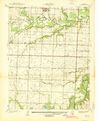
1939 Map of Metz
USGS Topo · Published 1939About this map
The Little Osage River and the Marmaton River define this rural landscape in western Missouri, where 1930s agriculture and rail transport intersect. The town of Metz serves as the primary hub, situated along the Missouri Pacific railroad line, while smaller settlements like Rinehart provide local structure to the farming districts. The map reveals a dense network of civic foundations including numerous country schools such as Old Metz Sch, Roundtop Sch, and West Washington Sch, which suggest the population density of the era before rural consolidation. Several family and community burial grounds, including Pryor Creek Cem and Summers Cem, are preserved on the sheet alongside centers of worship like Otterbein Chapel and Prairie Dell Ch. The presence of oxbows and sloughs like Townsend Slough indicates a dynamic river system that dictated early land use and settlement patterns.
Find a feature on this map
30 named features on this map. Tap any name to fly to it.
Don’t see what you’re looking for? This feature index may not catch every label — zoom into the map to look around manually.
Map Details
Editions of this 1939 Metz Map
2 editions found

Other maps of this area

1884 · Fort Scott
USGS Topo · 1:125,000

1886 · Nevada
USGS Topo · 1:125,000

1886 · Fort Scott
USGS Topo · 1:125,000

1887 · Butler
USGS Topo · 1:125,000

1887 · Mound City
USGS Topo · 1:125,000

1893 · Fort Scott
USGS Topo · 1:125,000

1893 · Mound City
USGS Topo · 1:125,000

1894 · Butler
USGS Topo · 1:125,000

1894 · Nevada
USGS Topo · 1:125,000

1933 · Camp Clark
USGS Topo · 1:24,000