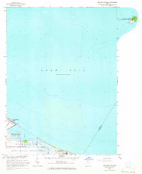
1964 Map of Metzger Marsh
USGS Topo · Published 1965About this map
Lake Erie dominates this mid-1960s survey, illustrating the complex intersection of shoreline ecology and water management in Jerusalem township. The map details a significant concentration of protected wetlands and conservation areas, including the Metzger Marsh Wildlife Area and the Ottawa National Wildlife Refuge. These marshlands are bisected by Wards Canal, which serves as a vital hydrological link to the lake near the small settlement at Howard Farms Beach.
Find a feature on this map
19 named features on this map. Tap any name to fly to it.
Don’t see what you’re looking for? This feature index may not catch every label — zoom into the map to look around manually.
Map Details
Editions of this 1964 Metzger Marsh Map
This is the sole edition of this map. No revisions or reprints were ever made.
Other maps of this area

1900 · Maumee Bay
USGS Topo · 1:62,500

1900 · Oak Harbor
USGS Topo · 1:62,500

1912 · Monroe
USGS Topo · 1:62,500

1914 · Monroe
USGS Topo · 1:62,500

1934 · Reno Beach
USGS Topo · 1:24,000

1935 · Genoa
USGS Topo · 1:24,000
1938 · Reno Beach
USGS Topo · 1:31,680
1938 · Genoa
USGS Topo · 1:31,680
1952 · Genoa
USGS Topo · 1:24,000

1952 · Oak Harbor
USGS Topo · 1:24,000