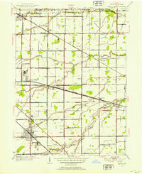
1952 Map of Genoa
USGS Topo · Published 1953About this map
Genoa serves as the primary hub of this landscape at the intersection of the New York Central railroad and numerous arterial roads like the Genoa-Clay Center Road. The territory is defined by its agricultural grid and the slow movement of the Packer Creek and Toussaint Creek drainage systems. Near Clay Center, a large Quarry operation and the Clay Center Sch indicate a concentrated pocket of industrial and civic life. The transit network is particularly dense here, featuring the New York Chicago and St Louis line cutting diagonally through smaller hamlets such as Martin and Elliston. Notable landmarks for local historians include the Airway Beacon in the southern reaches and the Williston Cem, which anchors the northwestern settlement of Williston.
Find a feature on this map
51 named features on this map. Tap any name to fly to it.
Don’t see what you’re looking for? This feature index may not catch every label — zoom into the map to look around manually.
Map Details
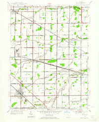
Editions of this 1952 Genoa Map
2 editions found
Other maps of this area

1900 · Maumee Bay
USGS Topo · 1:62,500

1900 · Oak Harbor
USGS Topo · 1:62,500

1901 · Fremont
USGS Topo · 1:62,500

1901 · Elmore
USGS Topo · 1:62,500

1903 · Fremont
USGS Topo · 1:62,500

1903 · Elmore
USGS Topo · 1:62,500

1934 · Reno Beach
USGS Topo · 1:24,000

1934 · Point Place
USGS Topo · 1:24,000

1935 · Walbridge
USGS Topo · 1:24,000

1935 · Genoa
USGS Topo · 1:24,000