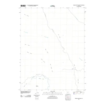
2011 Map of Mexican Mountain
USGS Topo · Published 2011About this map
The San Rafael River carves a winding path through the heart of the San Rafael Swell, creating the dramatic geological features known as Mexican Bend and the Black Box. This desert landscape is defined by the massive uplift of the San Rafael Reef and the towering presence of Mexican Mountain. The map illustrates a high-desert environment where drainage systems like Cottonwood Wash, Lost Spring Wash, and Tidwell Draw have shaped the earth over millennia, alongside broad plateaus such as Horse Heaven and Calf Mesa. Human presence is sparse in this 2011 survey, marked primarily by the lonely Smith Cabin and primitive routes like Cottonwood Wash Rd and San Rafael River Rd. These tracks follow the natural contours of the canyons and washes, providing access to the deep recesses of Nates Canyon and Spring Canyon in one of the most secluded portions of the American West.
Find a feature on this map
16 named features on this map. Tap any name to fly to it.
Don’t see what you’re looking for? This feature index may not catch every label — zoom into the map to look around manually.
Map Details
Editions of this 2011 Mexican Mountain Map
This is the sole edition of this map. No revisions or reprints were ever made.
Other maps of this area

1885 · San Rafael
USGS Topo · 1:250,000

1886 · Price River
USGS Topo · 1:250,000

1896 · Price River
USGS Topo · 1:250,000

1953 · Red Plateau SE
USGS Topo · 1:24,000

1953 · Beckwith Peak SW
USGS Topo · 1:24,000

1953 · Tidwell 2 NW
USGS Topo · 1:24,000

1954 · Stinking Spring Creek 1 NE
USGS Topo · 1:24,000

1954 · Tidwell 2 NE
USGS Topo · 1:24,000

1954 · Tidwell Bottoms
USGS Topo · 1:62,500
1954 · The Wickiup
USGS Topo · 1:62,500